Courses
Remote Sensing for Environmental Analysis
Fall 2022 ENV 558 (prev 857] 4 credits T,Th
SYLLABUS
Environmental analysis using primarily satellite remote sensing. Theoretical and technical underpinnings of remote sensing (georectification, image analysis, classification) coupled with practical applications (land cover mapping, change analysis, ground truth techniques). Strong emphasis on hands-on processing and analysis. Will include variety of image types: multi-spectral, hyper-spectral, radar and others.
Prerequisite: Some GIS experience or consent of instructor.
COURSE OBJECTIVES: To develop an understanding of the different techniques that may be utilized in computer processing of remotely sensed data and the characteristics of products obtained; To learn various approaches for developing thematic and continuous data products from remotely sensed data, including the use of field data and the impact of different approaches on results; To develop an understanding of the characteristics of a variety of sensor systems and understand the different processing approaches suitable for each; To develop the capacity to read the remote sensing literature critically.
LAB ASSIGNMENTS & PROJECT: It is assumed that students will work on assignments alone- ideas and approaches can be discussed with others, but you are expected to carry each lab assignment out by yourself and produce your own dataset/results. Many labs will not produce identical results for everyone.
Software: ENVI, Google Earth Engine, ArcPro
QGIS Intro to open source GIS (EMERGING/ROTATING TOPIC IN GIS)
Spring 2022 1.5 credits ENV 590
This course will introduce emerging tools and techniques in the realm of geospatial analytics that are not covered in our existing coursework. The course will consist of hands-on training in the computer lab with lab reports and will also include a short independent project. These may be open source or proprietary, desktop/laptop based or cloud based packages. Examples include QGIS (free & open source), GoogleEarthEngine (free cloud-based open source), ArcGISOnline (cloud based, partially proprietary). The course may be repeated for different topics. Course Goals/Objectives The goal is to introduce students to alternative geospatial software and analysis approaches that are not covered in our existing coursework. Weekly hands-on exercises in the computer lab will introduce different components of a given software/approach. Over this 1.5 credit class, the goal is to make students independent users, comfortable enough to continue to explore and use the software beyond the classroom. Independence will be solidified by designing and implementing a short project.
Spring 2022 Draft Course Outline "Introduction to QGIS: Fully functioning free & open source GIS” QGIS vs. ESRI, Data import/export, Vector analysis, Raster analysis, Spatial analysis, Spatial interpolation, Heat maps, Time series, Multi criteria analysis overlays, Cartography/Map production, e.g. Mapping census data, species data, overlays of species richness Introducing QGIS linkages to Python, R (statistics), and web mapping
Lidar Remote Sensing ENV 590.54 (spring 2022) 1 credit
Hands on lidar processing with a selection of different software tools; reading and discussion of applications. Readings will be a mix of scientific literature and detailed web documentation and consist of practical applications for management. Selection of topics will involve student input. All class materials will be on a shared Box.duke.edu site (not sakai).Labs will primarily use ArcPro, LidR (R toolset).
Learning objectives: By the end of this course, you should be able to:
•Describe the principles of LiDAR systems.•Describe best practices for geo-referencing and processing LiDAR data.
•Critically evaluate trade-offs and limitations with respect to LiDAR sensors and decisions made in data processing workflows.
•Develop an inquiry-driven efficient data processing workflow that is appropriate to answer a research question.
•Use GIS and/or Fusion software to execute analysis.
•Produce a clear and professional presentation of findings.
Eyes in the Sky: Remote Sensing from Satellites to Drones (Spring 2021)
syllabus website
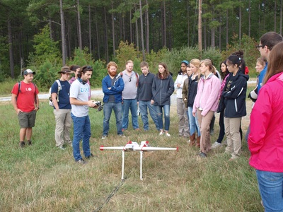
Team-based collaborative client project course introducing emerging remote sensing/drone technology methods, ecological-environmental measurements & validation Undergrad: STS, QS, NS
Professors: Dave Johnston & Jennifer Swenson
Online instruction with in-person field trips
Prereqs: familiarity with GIS is suggested, but not required.
Team project results storymaps/posters: **Scaling sea ice estimates for Minke whales **Counting deer with thermal sensing drones **Maritime Forest height-- lidar vs. drones **Mapping peruvian gold mining drones & Landsat ** Sea Turtles and coastal lights
Eyes in the Sky covers a good portion of the image processing done in ENV558[857]—so they overlap. Eyes in the Sky is a concentrated subset of image processing of optical imagery analyses that also integrates the use of drones, as well as a collaborative course group project. The fall 558 course covers more different types of imagery and analysis (satellite and airborne), but is very limited in terms of integration of drone technology. There are no hard prereqs for either course, but familiarity with GIS is recommended.
Land Conservation in Practice ENV 720S (spring) 1 credit
This course provides an overview of the applied skills and techniques currently used to conserve land in the land trust movement. We will cover a variety of topics from setting priorities for conservation, completing land transactions, working with private landowners, fundraising, land monitoring and stewardship, evaluating conservation success, etc. The course leverages the experience of guest speakers from regional land trust and conservation organizations to provide working examples of how land conservation is done. Students are expected to complete weekly readings in preparation for guest speakers, participate in a small group project, and attend a field trip in the Triangle to conserved lands.
Protected Areas/ Wilderness Management ENV 590.47 (occasional) 2 credits. Rotating topics of protected areas issues, management and ecology. Includes investigation of different management issues (e.g. human presence, resource extraction, climate change) both inside and outside protected area boundaries. May involve student teaching participation Prerequisite: one ecology course or ESC MEM. Limited to 18 students.


